7 January 2026

By Publisher Ray Carmen
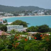
In the quiet coral plains of Anegada in the British Virgin Islands, scientists have uncovered striking geological evidence of a massive wave event that struck the Caribbean more than 600 years ago — long before the age of written records. Fragments of coral, found far inland and fossilized as skeletal remains, are now rewriting our understanding of ancient coastal hazards and offering a powerful reminder of the region’s seismic risk.
Researchers examining the coral deposits discovered that these once‑living colonies were carried hundreds of meters inland by extraordinary forces, then died and fossilized where the ocean normally never reaches. By precisely measuring the decay of radioactive elements such as uranium and thorium within the coral, scientists narrowed the timing of this event to a decade between 1381 and 1391 CE.
The leading explanation for the sudden displacement of these massive coral boulders is a tsunami triggered by a powerful earthquake — estimated to have exceeded magnitude 8.0 — originating in the Puerto Rico Trench, a deep geological fault zone where the North American and Caribbean tectonic plates meet.
Unlike hurricanes and tropical storms, which typically erode shorelines gently over decades, the immense force needed to dislodge living coral and fling it so far inland points clearly to a tsunami of rare but immense power. Modern computer models suggest the large earthquake would have generated waves capable of climbing far above the normal flood zone around Anegada.
While written history in the Caribbean only begins several centuries later, this coral‑recorded event proves that major tsunamis have struck the region in the distant past — and could again. That’s particularly important for low‑lying islands and coastal communities, where future infrastructure like schools, hospitals and homes may need to account for rare but catastrophic events in their planning and construction.
Geologists stress that these ancient clues aren’t just relics of the past — they offer a natural warning system. By studying these coral skeletons and integrating their evidence into hazard maps, policy makers and disaster planners can better prepare for the potentially devastating impacts of future seismic waves and earthquakes across the Caribbean basin.